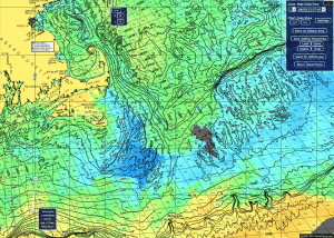
Unlike inshore fishing, there’s not a whole lot of structure in blue water. Other than a few contour lines you can follow, pretty much your only “structure” is created by warm water eddies that wash in from the Gulf Stream.
Depending on the species; some baitfish like warmer water and others like colder water; and these masses of warm water keep the baitfish corralled on either side depending on their preferences. As a result, the edges of these temperature breaks can hold some fantastic fishing.
 As any experienced offshore angler knows, locating these warm water masses or “fingers” makes all the difference in a day’s fishing offshore. Sometimes you’ll find a difference of two or three degrees over mile or two of surface and other times you can find a difference of up to 10 or 12 degrees. While I tend to favor bigger temp breaks, more times than not, just a difference of two or three degrees can indicate an area that holds fish.
Other than studying just the temperature variations, be sure to look at the shapes and sizes of the warm water moving in. Ideally, you’re looking for two things:
Fingers: Fingers are masses of water that move west, and inland from the Gulf Stream where warm water is continuously fed into the tip of the finger. Ideally you want to look for a large fingers of warm water, of at least 72 degrees edged by water in the mid to high 60s. Theses fingers of water serve as a highway of sorts for warm water pelagic species such as marlin, tuna and mahi mahi. On the corners you will often find bluefin tuna. Fingers are slow moving.
Eddies: Eddies are warm masses of water that pinch off from the Gulf Stream and are surrounded by cooler water. This occurs when a finger pinches off. Eddies can be hot when a population of fish stays with them, essentially making it easier to find the needle the proverbial haystack.
In either situation, the current from the Gulf Stream tends to push the water counter clockwise. Know this can be helpful, as most fish tend to swim with the tide as a result of the strength of the Gulf Stream currents. As a result, I prefer to troll with the tide.
Needless to say, sea temperature charts are essential tool in offshore fisherman’s arsenal. Before heading offshore it is essential to study a temperature chart. I like to create a plan a B and C, and know how far each of these spots are from each other. I’ll bring a print out copy with me with all the lats and longs for each but preload them into my GPS before leaving the dock.
For me, that’s where commercially available ocean temperature charts come into play. Their satellite feeds are great, the reports print out perfectly. Oceantemp has a handy little tool built in that allows you to build waypoints labeled with lat/long and sea temps and measure the distance between them and also labels the compass heading on a printout.
If you are a little nerdy like myself, you can learn much from the archived temp charts. Oceantemp has easy access and you can play them in a slide show, which is a great way to study the movements of the eddies or fingers pushing west, inland.
This service is only about $140 per season. I realize there are a number of services out there but this one has never failed me and is super easy to use.
It is Hogy Approved!
Cheers,
Mike
